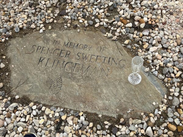
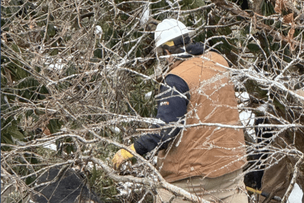
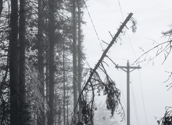
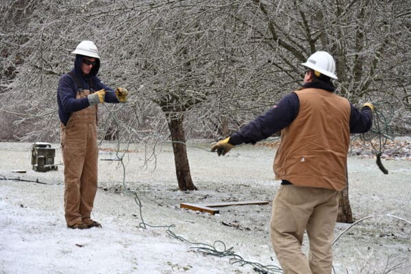
1000 x 90

Grandfather Mountain January Weather Report

March 1, 2024 January 2024 saw quite a bit of snowfall on Grandfather Mountain, as well as some blustery conditions, according to data recorded at the park’s official weather reporting stations. The average high temperature for January 2024 was 34.30 degrees Fahrenheit, with an average low of 20.64 degrees and a mean of 27.47 degrees. The warmest temperature recorded last month was 53.2 degrees on Jan. 26, just under 12 degrees shy of the mountain’s record January high of 65 degrees, observed on Jan. 30, 2002.  Jan. 21 saw the coldest temperature recorded last month with minus 5.1 degrees. A wind chill of minus 34.41 was noted that same day.

Read more

Grandfather Mountain’s 2023 Weather in Review

January 31, 2024  Grandfather Mountain is a rugged place known for its wild and fast-changing weather. While no records were set or broken in 2023, the year saw many noteworthy monthly totals, according to data collected at the nature park’s official weather reporting stations near the Mile High Swinging Bridge and Wilson Center for Nature Discovery. Some notable observations, and how they compare to Grandfather’s 69 years of recorded data, are included in the story.

Read more

Grandfather Mountain December 2023 Weather Report; Quite a Bit of Rainfall Recorded

January 22, 2024  December 2023 saw quite a bit of rainfall on Grandfather Mountain, according to data recorded at the park’s official weather reporting stations. The average high temperature for December 2023 was 40.41 degrees Fahrenheit, with an average low of 28.91 degrees and a mean of 34.66 degrees. The warmest temperature recorded last month was 52.7 degrees on Dec. 2, more than 10 degrees shy of the mountain’s record December high of 63 degrees, observed on Dec. 7, 1956. Generally, December sees winter weather conditions set in on Grandfather Mountain.

Read more

Grandfather Mountain September 2023 Weather Report                                 

November 2, 2023 LINVILLE, N.C. – September 2023 saw fairly average weather on Grandfather Mountain, according to data recorded at the park’s official weather reporting stations.The average high temperature for September 2023 was 62.06 degrees Fahrenheit, with an average low of 52.35 degrees and a mean of 57.21 degrees.The warmest temperature recorded last month was 74.5 degrees on Sept. 5, over four degrees shy of the mountain’s record September high of 79 degrees, observed Sept. 24, 2010. Generally, September sees fall weather conditions take hold on Grandfather Mountain, with cooler temperatures arriving.

Read more

Tornado Touches Down in Avery County August 15

August 16, 2023 An extremely rare tornado has been confirmed to have touched down in Avery County this week by the National Weather Service’s regional headquarters in Greer, South Carolina, and by the National Oceanic and Atmospheric Administration (NOAA), a Washington, D.C.–based scientific and regulatory agency within the United States Department of Commerce charged with forecasting weather and monitoring atmospheric conditions. By Tim Gardner

Read more

Grandfather Mountain June 2023 Weather Report

July 28, 2023 This past June was among the coolest on record on Grandfather Mountain, according to data recorded at the park’s official weather reporting stations. The average high temperature for June 2023 was 61.16 degrees Fahrenheit, the third-lowest on record. The 68-year coolest average high temperature on record at Grandfather is 60.27 degrees in 1997. Meanwhile, the average low of 50.94 degrees was the eighth-lowest on record, while the mean of 56.05 degrees was the fifth-lowest on record for this month.

Read more

Grandfather Mountain September 2022 Weather Report

October 20, 2022 LINVILLE, N.C. – September 2022 saw average weather on Grandfather Mountain, according to data recorded at the park’s official weather reporting stations. The average high temperature for September 2022 was 61.1 degrees Fahrenheit, with an average low of 49.2 degrees and a mean of 54.5 degrees.

Read more

Winter Pays a Spring Visit to the High Country with a Weekend of Snow

April 10, 2022 The first day of spring was March 20, but that doesn’t mean winter weather was ready to go! Folks across the High Country were able to experience some April flurries over the weekend, with different areas receiving various amounts of snow. According to Ray’s Weather Center, between Friday and Saturday, Boone received trace amounts of snow at night totaling about .5 inches. However, in areas of higher elevations such as Sugar Mountain, the amounts totaled more like 5 inches. Fred Pfohl of Fred’s General Mercantile reported that the top of Beech Mountain received almost 8 inches.  By Harley Nefe

Read more

High Country Weekly Weather Forecast: Slightly Warmer Temperatures and a Break from the Snow?

January 31, 2022 Boone and the rest of the High Country might get short break from the bone-chilling temperatures and wind chills that have gripped the area for the last couple of weeks. According to the latest forecast from Ray’s Weather Center, high temperatures will be in the 40’s most of the week and might even cross 50 degrees on Thursday. The week will also be relatively dry with a chance of rain overnight Wednesday and some rain showers Thursday before a weather front moves through the area Thursday night and Friday morning. There might be a slight chance of snow in the early morning hours of Friday if temperatures cooperate. Today’s forecast is mostly sunny with a high of 44 degrees. Tuesday will also be sunny with clouds arriving late in the day. The high is expected to be around 43 degrees. Wednesday will feature a high of 46 degrees and Thursday the high is forecasted to reach 51 degrees. High temperatures drop back into the mid-40s for Friday and into the upper 30s on Saturday.  By Nathan Ham

Read more

High Country Weekly Weather Forecast: Cold Temperatures Remain With a Slight Chance of Snowfall Expected This Week

January 24, 2022 The High Country will get a break from wintry precipitation for most of this week as it appears temperatures will remain cold but it will be dry until a chance of snow showers on Friday. According to the weather forecast for Boone from Ray’s Weather Center, the week begins with a mix of sun and clouds today with a high temperature of 42 and an overnight low of 29 degrees. Tuesday looks like the warmest day of the week with a high predicted to reach 45 degrees. There is a slow chance of some snow flurries overnight as the temperature sharply drops into the teens. Wednesday looks like the coldest day of the week as it will be sunny but the high will be just 33 degrees and the low is expected to drop down to 14 degrees. It warms up just a bit on Thursday with a high of 38 degrees and a low of 25 degrees. A chance of snow showers returns to the forecast on Friday with highs in the mid-30s and lows in the teens. By Nathan Ham

Read more

High Country Weekly Weather Forecast: More Snow Showers Possible Later This Week

January 17, 2022 If you didn’t get your fill of snow this weekend across the High Country, it appears another winter weather event is on tap later this week into the weekend. According to the latest weather forecast from Ray’s Weather Center, snow showers will hang around throughout the day today as well as increased winds with gusts up to 60 MPH. Tuesday and Wednesday will be the clearest days of the week with a mix of sun and clouds. Wednesday is also shaping up to be the warmest day of the week with a high temperature of 44 degrees. There will be a slight chance of rain on Wednesday night before snow showers return to the forecast on Thursday, Friday and Saturday. Temperatures will warm up a bit Tuesday and Wednesday before turning sharply colder again on Thursday. The high temperature will be around freezing on Thursday and will not get out of the 20s on Friday or Saturday. Lows will be around 12 degrees on Thursday night and 10 degrees on Friday and Saturday nights.  By Nathan Ham

Read more

Winter Storm Izzy Expected to Greatly Impact the High Country This Weekend; National Weather Service Predicting 5-12 Inches of Snow Saturday Night Through Monday Morning

January 14, 2022 It might have taken a little while for winter to show up in the High Country after an unseasonably warm December, but another round of snow is heading towards the area with what is anticipated to be the biggest snowfall of the season. The National Weather Service has issued a Winter Storm Watch from late Saturday night through Monday morning as Winter Storm Izzy barrels its way east. The NWS is expecting snow to fall, heavy at times throughout the day Sunday and Sunday night before coming to an end Monday morning. The NWS forecast is predicting 5-12 inches of snow for almost all parts of the High Country with higher totals at higher elevations such as Beech Mountain and Sugar Mountain. Right now, the storm system is centered over Iowa and Minnesota and will continue to head southeast. On Saturday, the storm will be crossing Illinois, Missouri and Kentucky before arriving in Tennessee, Virginia, North Carolina and South Carolina in the overnight hours Saturday heading into Sunday.   By Nathan Ham

Read more

Wind Chill Advisory and Special Weather Statement Issued; Watauga County Schools Operate on Remote Learning Day Friday

January 7, 2022 The coldest day of the season has arrived as people across the High Country wake to temperatures in the teens on Friday morning. While the previous Winter Weather Advisory from Thursday, January 6, has been canceled, the National Weather Service has since issued a Wind Chill Advisory that remains in effect until 1 p.m. on January 7 for Watauga and Ashe counties. According to the alert, wind chills as low as 15 below zero are expected. Wind Chill Advisories are issued when strong winds combine with cold temperatures for several hours to create dangerously cold conditions, according to the National Weather Service. By Harley Nefe

Read more

Winter Weather Advisory Begins at 1 p.m., Watauga County Schools Releasing Early at Noon

January 6, 2022 Just as the last snowfall began to melt, wintry precipitation will return to the High Country on Thursday afternoon and continue overnight. According to the National Weather Service, a Winter Weather Advisory will be in effect from 1 p.m. today through 7 a.m. on Friday morning. Snowfall totals will range from 2-4 inches for most of the High Country with higher elevations receiving higher snow totals. Wind gusts as much as 35 MPH are possible, which also means wind chills could be as low as five degrees below zero according to the NWS. In preparation for the incoming snow, Watauga County Schools have decided to dismiss classes early. K-8 schools will dismiss at noon and the high school will dismiss at 1 p.m.  Buses will travel the same routes this afternoon that were traveled this morning. The latest forecast from Ray’s Weather Center shows temperatures dropping into the teens overnight as snow will continue to fall. The highest snow totals will be along the Tennessee state line according to the forecast. Most of the snow will fall tonight before ending with a few snow flurries on Friday morning. By Nathan Ham

Read more

Ray’s Weather Center Shares its Fearless Winter Forecast for the 2021-22 Season

October 15, 2021. It’s that time of year again to be thinking about the winter season, and Ray Russell, the founder of Ray’sWeather.com, just released his Fearless Winter Forecast for the 2021-22 winter season. “The winter setup looks a lot like last year with just subtle differences in the forecast,” Russell said. “Last year’s forecast worked out great, it was at least in the top one or two forecasts that we’ve ever done.” Both this winter and last winter will be La Nina years with last year being stronger than this year according to Russell. “La Nina years mean a little less snow than average so we put the forecast less than the long-term average but more than the last 10-year average,” he said. “The thing that was missing last year is we have had a couple of years where we just haven’t had any northwest flow snow events where we get the strong northwest winds and moisture off of Lake Michigan or Lake Erie where it would snow on the mountain tops for days at a time.” By Nathan Ham

Read more

Temperatures Expected to Drop Midweek with a Chance of Snow Possible on Wednesday

April 19, 2021 Warmer spring temperatures will not be in the forecast this week as they have previously for the High Country. Cold weather is forecasted to take over on Tuesday night, bringing a chance of snow at higher elevations on Wednesday afternoon. Tuesday will be the nicest day of the week with a high around 60 and some sunshine. After that, however, a cold, wintery feel is back in the forecast. According to the latest forecast from Ray’s Weather Center, the low will drop to 40 on Tuesday night with some light rain moving into the area overnight. On Wednesday, temperatures will drop throughout the day, as lingering rain showers may turn to snow showers during the afternoon. The low temperature is expected to drop into the 20s for Wednesday and Thursday nights with highs in the mid to upper 40s.  By Harley Nefe

Read more

Fast Moving Tropical Storm Zeta Drops Around 3 Inches of Rain Across the High Country Overnight


October 29, 2020  Watauga County has been issued a Tropical Storm Warning and Flash Flood Warning from the National Weather Service in Blacksburg, Virginia, as Tropical Storm Zeta moves from North Georgia northeastward through East Tennessee this morning. The Tropical Storm Warning will remain in effect until further notice, and the Boone and Blowing Rock locations are affected. The Flash Flood Warning will remain in effect today, Oct. 29, until 2:45 p.m. Tropical Storm Zeta is moving quickly northeast, and rain will taper to light showers by this afternoon. Since 12 a.m. Oct. 29, Boone has received 2.29″ of rain, and Blowing Rock has received 3.40″. By Harley Nefe

Read more

Cold Weather is Back in the Forecast After an Unseasonably Warm Christmas Week; Snow Possible this Weekend

December 30, 2019. So far it has been a very mild winter in the High Country with the warmest temperatures of December being recorded just last week. According to David Still at Ray’s Weather Center, temperatures flirted with record highs last week but came up just a bit shy. The record for Christmas Eve in Boone is 63 degrees. Last week, the high on Christmas Eve reached 61 degrees. The warmest Christmas on record was at 62 degrees and the temperature just missed tying that record coming in at 61 degrees. Last week’s temperatures fell well short of the all-time December high record in Boone which was 73 degrees in 1939. The average high for this time of year in Boone is 45 degrees and the average low is 26 degrees. Temperatures have been well above those averages for seven straight days.  By Nathan Ham

Read more

Heavy Rains Across the High Country Cause Major Flooding Issues Over the Weekend


June 10, 2019. Steady rains arrived on Thursday and hung around the High Country all weekend long, bringing along with it some serious flooding issues in Watauga, Avery and Ashe counties. Many roads were closed and even some of the main highways in and out of Boone had brief lane closures, including Highway 421 in Deep Gap where a mudslide closed one lane. One of the hardest hit areas in Watauga County was Valle Crucis where approximately seven inches of rain fell and left much of the Valle Crucis Community Park underwater. and many side roads closed. Valle Crucis Elementary School was also hit hard again in the storm as is typical for large rainfall events such as this one. “We saw impacts from this weekend’s storms across the county affecting several of our schools in different ways. Valle Crucis was affected most directly. We saw flooding there that’s unfortunately very typical for this type of storm at that school. Several classrooms in the lower lying areas of the school were flooded with groundwater,” said Garrett Price, Director of Communications for Watauga County Schools.  By Nathan Ham

Read more

Early Spring Flowers Show Up Just in Time For Another Blast of Arctic Cold


March 4, 2019 Unfortunately for the early flowers that sprouted up over the last couple of weeks of warmer weather, this week looks like nothing but cold weather with snow and rain showing up at the end of the week. High Country residents were greeted with snow flurries and temperatures in the 20s on Monday morning, an ominous start to the week for those that are ready for spring temperatures. Monday’s forecast from Ray’s Weather Center expects it to be a chilly week. By Nathan Ham

Read more

March Begins With More Wet Weather in the High Country; Snow Showers Possible Next Week: See Snow Totals For the Season So Far Here

March 1, 2019 We are 19 days from the first day of spring, but with temperatures in the 50s and more rain showers happening to close out the workweek, it might feel like spring is already here. For those that want another burst of cold air, next week will provide weather more fitting of the winter season. According to the upcoming weather forecast from Ray’s Weather Center, Saturday looks to be a nice day with a mix of sun and clouds and high temperatures reaching into the lower 50s. Rain returns to the forecast on Sundays and temperatures will begin dropping throughout the day before bottoming out in the upper 20s with rain changing to some snow flurries late. Monday and Tuesday with have highs barely getting to freezing and low temperatures hanging around in the teens. The story remains the same for Wednesday and Thursday with high temperatures in the 30s and lows in the 20s. Snow flurries or snow showers are in the forecast for Monday through Thursday. By Nathan Ham

Read more

Winter Storm Warning Issued for Tuesday Evening Through Wednesday Evening


February 18, 2019 A wintry mix of snow, sleet and freezing rain is expected to cover the High Country on Tuesday and Wednesday, prompting the National Weather Service to issue a Winter Storm Warning from 6 p.m. Tuesday until 4 p.m. on Wednesday. The NWS alert says that heavy mixed precipitation is expected through southwest Virginia and northwest North Carolina, starting late Tuesday afternoon and continuing through most of the day on Wednesday. This is not expected to be a big snow even with just an inch or two of accumulation, however the icing hazard is the main issue with this storm. Ice accumulations up to two tenths of an inch are possible, which will make travel conditions hazardous and increase the chances of tree damage or power outages for downs trees and power lines. By Nathan Ham

Read more

High Country Prepares for First Winter Storm of the Season; Information on School Closing Policies


November 14, 2018. A Winter Storm Warning has been issued for Watauga, Ashe and Avery counties through Thursday afternoon as the first winter storm rolls through the area on Wednesday night and Thursday morning. A wintry mix is expected to begin late this afternoon and this evening. The biggest threat from this storm will be the sleet and ice potential. According to the National Weather Service, sleet accumulations could reach as much as two inches and ice accumulations reaching a half-inch. There may be some snow mixing in with this storm, however ice will be the biggest factor overnight. Wind speeds will also pick up with this storm. Wind gusts between 20-35 MPH could bring down trees and power lines that may be covered in ice. By Nathan Ham

Read more

First Week of Spring is in the Books; Boone Received Over Six Inches of Snow

March 27, 2018. Spring rolled into the High Country last week, bringing snow, sleet and freezing rain to all parts of the area, leaving a little over six inches of snow in Boone. Other areas, such as Sugar Mountain and Beech Mountain, received upwards of eight inches of snow during the off-and-on winter precipitation last week. Saturday’s wintry mix forced the postponement of several events in Boone, including the High Country Grizzlies game and the Banff Film Festival. Saturday’s events for the Banff Film Festival have been rescheduled for Tuesday evening. There has been no announcement from the Grizzlies about rescheduling their game. By Nathan Ham

Read more