
By Jesse Wood
Aug. 30, 2013. The master plan for the Middle Fork Greenway, a multi-use greenway trail that will connect the Town of Boone and Blowing Rock, was recently completed by Destination by Design, a local outdoor planning, design and promotions firm.
This trail will be a part of the New River Headwaters Trail, a network of three trails – Middle Fork Greenway, Boone Greenway and South Fork Greenway – connecting Boone, Blowing Rock and Todd, which is a project of High Country Pathways, an incorporated nonprofit specializing in trails, greenways and blueways throughout Watauga County.
This Middle Fork Greenway portion of the trail has been a long time coming.
In 2000, the Middle Fork Greenway Association, which is a part of High Country Pathways, formed to promote the project and build the public support necessary to acquire land, easements, funds and permits for the greenway trail connecting Boone and Blowing Rock.
So far, Eric Wooldridge, a board member of the Middle Fork Greenway Association and a partner of Destination by Design, said that about 10 percent of the Middle Fork Greenway project is either completed and/or construction is to begin soon.
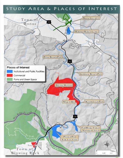
As for the master plan, it breaks the 6.5-mile project into six planning sections with manageable project phases.
Section 1: Blowing Rock
- Begins at future U.S. 321 parking area/Tanger Outlets and ends at the Planned Post Acute Care Facility near the bridge to the Blue Ridge Parkway
Section 2: Firethorn
- Begins at the Planned Post Acute Care Facility and ends at the FaithBridge Untited Methodist Church/Aho Road
Section 3: Three Rivers
- Begins at the FaithBridge Untited Methodist Church/Aho Road and ends at Sterling Creek Park
Section 4: Tweetsie
- Begins at Sterling Creek Park and ends at Goldmine Branch Park/Niley Cook Road
Section 5: Cook to Cook
- Begins at Goldmine Branch Park/Niley Cook Road and ends at Jordan V. Cook Road/Town of Boone Municipal Boundary
Section 6: Boone
- Begins at Jordan V. Cook Road/Town of Boone Municipal Boundary and ends at Boone Greenway Access/Deerfield Road
Click here to read details about each section and peruse the entire Master Plan: http://issuu.com/dbdplanning/docs/middle_fork_greenway_master_plan
The “Strategic Direction” section in the Master Plan notes that Goal #1 is to finalize phase 1 construction of the section called “Tweetsie,” the section that connects the Tweetsie Railroad theme park to Sterling Creek Park.
Goal #2 is to establish the “Blowing Rock” section as the official Phase 2 section and to begin preliminary engineering. High Country Pathways received a technical services grant through the Community Transformation Grant Project to assist with preliminary engineering of this section. Then after finalizing any deeds with the Watauga County Register of Deeds, then project leaders will prepare and submit for Recreation Trails Program funding that could provide up to $50,000 in matching funds.
Goal #3 is to establish a Landowner Outreach Committee comprised of three Middle Fork Taskforce representatives to coordinate and direct all communications with landowners on behalf of the Taskforce to begin on the other sections of the proposed Middle Fork Greenway Trail.
Goal #4 is to meet with officials at the state and local level and outline the plan.
Goal #5 is to develop a financial plan for implementing the Middle Fork Greenway and conduct estimates of probable costs for each planning section and create realistic fundraising goals.
The Master Plan outlines hundreds of thousands of dollars worth of grants with some requiring up to a 50 percent match.
Click here to peruse the entire Master Plan: http://issuu.com/dbdplanning/docs/middle_fork_greenway_master_plan
You must be logged in to post a comment.