By Jesse Wood
June 13, 2014. Social media was buzzing about a loud boom that was heard and felt in the High Country at about 1:30 p.m. on Thursday afternoon.
Juliana Harrison posted on Watauga County Road Conditions Facebook page: “Heard a loud boom and felt the ground shaking at AppalCart on 105 Bypass… We initially thought it was thunder from the approaching storm.”
Dozens of other folks posted similar thoughts. While the U.S. Geological Survey didn’t immediately report that an earthquake took place, it has now officially recorded the event on its website.
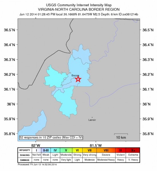
The earthquake with a magnitude of 2.5 happened at 1:28 p.m. Its epicenter was 2 miles northeast of Blowing Rock and four miles southeast of Boone. According to its “Did You Feel It?” community response page, 59 people from 10 different zip codes let the U.S. Geological Survey know that they did, in fact, feel it.
On a “shaking scale” of not felt to extreme, the USGS rated Thursday’s earthquake in the weak to light range.
The last earthquake to occur in the area was in early May, when a magnitude 2.3 earthquake shook the Boone area. In August 2013, a 2.9 magnitude quake with an epicenter 2 miles northeast of Blowing Rock rattled the are – in the vicinity of Thursday’s quake.
In November 2012, a 4.3 magnitude earthquake rattled the High Country. However, the epicenter of that quake was in Eastern Kentucky, about 100 miles from Boone.
Here is a summary of the earthquake that occurred in Blowing Rock in August 2013 from a geologist at Appalachian State University. The geologist who posted that summary couldn’t immediately be reached on Friday morning.
Below is a Tectonic Summary of the region from the USGS.
Earthquakes in the Inland Carolinas Region
Since at least 1776, people living inland in North and South Carolina, and in adjacent parts of Georgia and Tennessee, have felt small earthquakes and suffered damage from infrequent larger ones. The largest earthquake in the area (magnitude 5.1) occurred in 1916. Moderately damaging earthquakes strike the inland Carolinas every few decades, and smaller earthquakes are felt about once each year or two.
Earthquakes in the central and eastern U.S., although less frequent than in the western U.S., are typically felt over a much broader region. East of the Rockies, an earthquake can be felt over an area as much as ten times larger than a similar magnitude earthquake on the west coast. A magnitude 4.0 eastern U.S. earthquake typically can be felt at many places as far as 100 km (60 mi) from where it occurred, and it infrequently causes damage near its source. A magnitude 5.5 eastern U.S. earthquake usually can be felt as far as 500 km (300 mi) from where it occurred, and sometimes causes damage as far away as 40 km (25 mi).
Faults
Earthquakes everywhere occur on faults within bedrock, usually miles deep. Most bedrock beneath the inland Carolinas was assembled as continents collided to form a supercontinent about 500-300 million years ago, raising the Appalachian Mountains. Most of the rest of the bedrock formed when the supercontinent rifted apart about 200 million years ago to form what are now the northeastern U.S., the Atlantic Ocean, and Europe.
At well-studied plate boundaries like the San Andreas fault system in California, often scientists can determine the name of the specific fault that is responsible for an earthquake. In contrast, east of the Rocky Mountains this is rarely the case. The inland Carolinas region is far from the nearest plate boundaries, which are in the center of the Atlantic Ocean and in the Caribbean Sea. The region is laced with known faults but numerous smaller or deeply buried faults remain undetected. Even the known faults are poorly located at earthquake depths. Accordingly, few, if any, earthquakes in the inland Carolinas can be linked to named faults. It is difficult to determine if a known fault is still active and could slip and cause an earthquake. As in most other areas east of the Rockies, the best guide to earthquake hazards in the seismic zone is the earthquakes themselves.


You must be logged in to post a comment.