By Paul T. Choate
Jan. 4, 2013. Wild weather was the story during much of 2012. Unseasonably warm temperatures to the tune of the mid-70s by March and some record-breaking winds kept the High Country community enthralled with what Mother Nature would do next.
Working off weather data from Ray’s Weather Center’s (RWC) archives of the weather station at Footsloggers in Boone, we will start by looking at some temperature extremes.
Temperatures
 July is traditionally the hottest month of the year, with the average high around 78 degrees. However, on a day in late June, the thermometers recorded a 50-year (at least) high. At 5:23 p.m. on July 29, the Footsloggers weather station recorded a blistering 93.2 degrees – the highest temperature for that day by more than five degrees since at least 1963.
On the colder side, Boone recorded the coldest temperature of 2012 early in the year. On Jan. 26 at 12:38 p.m., the temperature hit the zero degrees mark. This was a 50-year low for that date in Boone, according to RWC, with the coldest prior Jan. 26 coming in 1978 when the temperature dipped to two degrees. Though subzero temperatures were recorded at higher elevations around the High Country, Boone never dipped below that mark in 2012.
Precipitation
Shifting focus to rain, RWC recorded a total of 43.16 inches of precipitation in 2012, or an average of around 3.6 inches per month. April was Boone’s wettest month, tallying 5.61 inches. The driest month of 2012 was June, with only 1.47 inches of rainfall. This is highly unusual for the High Country, given that June and July are historically months that get the highest average number of days with rainfall, according to the National Oceanic and Atmospheric Administration (NOAA).
Wind sets records
 Wind was also a big story – perhaps the biggest – in 2012. Based on data from the Footsloggers weather station, the highest wind speed of the year came recently, on Dec. 27 at 3:20 a.m., to the tune of 51 mph. That, however, is not indicative of just how windy it was.
Wind gusts recorded by the anemometer located on the Mile High Swinging Bridge at Grandfather Mountain reached 120.7 mph on Dec. 21. This was a new three-second gust record for the mountain. The previous highest three-second gust on Grandfather was 114.7 mph recorded Jan. 26, 2011.
A ‘Superstorm’ hits
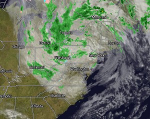
And what would a weather roundup story be if we didn’t mention Superstorm Sandy, which thrashed the High Country with high winds and snowfall during late October.
The storm carved a path of destruction along the East Coast and although the High Country didn’t suffer like those in the northeast, there was still significant damage from the winds, traffic gridlocks from the snow and the tragic death of Jonathan Brad Markland, 37, of Roan Mountain, Tenn. Markland lost his life in a traffic accident in Banner Elk on the morning of Oct. 30 during heavy snowfall.
The snowfall amounts shattered records for the month of October in places around the High Country during the storm according to RWC. The following snowfall amounts are all courtesy of RWC:
| Watauga County | Avery County | Ashe County |
|---|---|---|
| Boone 5″-6″ | Elk Park 14″ | Todd (Laurel Mtn) 4″-5″ |
| Zionville 8″-10″ | Beech Mtn 12.5″ | Clifton 14″ |
| Sugar Grove 8.5″ | Sugar Mtn 12 | Warrensville 5″ |
| Valle Crucis 6″ | Newland 7″ | West Jefferson 4″ |
| “321 at the state line” 7″ | Glendale Springs 2″ | |
| Flat Springs 7″ | ||
| Plumtree dusting |
Historically, according to RWC, the most snow Boone had ever received in October prior to this event was three inches on Oct. 22-23, 1937. Banner Elk’s record was six inches on two separate occasions, Oct. 29, 1908 and Oct. 23-24, 1923.
Your weekend outlook
So what’s next in terms of the ever-unpredictable weather in the High Country? Well, currently the temperature is 34.4 degrees in downtown Boone and the forecast isn’t suggesting it will get much warmer today. The winds will remain gusty, hovering around the 20 mph mark or a little more.
Tomorrow will be slightly warmer, with a high projected to be 45 degrees. Snow flurries or a light wintery mix could be possible in the overnight hours tomorrow, especially at the higher elevations.
Sunday looks relatively pleasant, though still chilly with a high expected to be 42 degrees. There may be some snow flurries in the morning but those are expected to taper off. Flurries could return in the overnight hours Sunday.
On Monday, Jan. 7, you will start the workweek with temperatures still in the low to mid 40s. The forecast is projecting mostly clear skies with only patchy clouds.
To stay on top of what the weather is doing around the area, visit raysweather.com.


You must be logged in to post a comment.